
The spirit of adventure and exploration doesn’t have to be super dangerous and difficult sometimes it’s just going a different route or somewhere you have not been before. That’s not to say planning and preparation are not important either. One of the great things about San Diego’s backcountry is an area you have been to many times can still have a few surprises up its sleeve.
This last trip was Anza Borrego and Mine Wash Road a great little spot this time of year with a ton of history. Triple B Adventures a local nonprofit that gets veterans and active duty out hunting hiking and fishing has been coming here for years and our buddy Brady Pesola from the Gray Man Project turned us on to this spot. At times it can be a little difficult to find and the reception is iffy (not always a bad thing) this area is great for camping has a vault toilet and most notably is the site of a Native Village Site the Kumeyaay would winter in next to an amazing bolder field that offers some interesting exploration.

What makes Mine Wash Road interesting is that it dead ends and on the map picks up again and ends in Shelter Valley. I love maps by the way they are a great way to find new spots, plan trips and find a little adventure here and there. My go to for this area is the Tom Harrison “San Diego Backcountry: Anza-Borrego Desert State Park Recreation Map”. This map is what inspired us to hike the road and check out a new area.

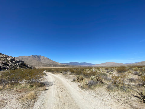
Brady and I planned it out and left an itinerary with the group especially since we had questionable cell service and while yes this is a road there is always the uh-oh factor. The route we would be taking had us leaving a car at one end and hiking to the other. The whole road its self is around seven miles which has a decent climb the first couple miles then drops in the hills and down into the valley for a nice leisurely stroll. We drove my 2WD Silverado a couple miles in with little trouble and a lot of paying attention as parts of the road definitely need a truck with some clearance.

Once we thought we were in a good spot I could get the truck out of we dismounted and began our hike. The road downhill defintly became a 4WD road (glad I parked when I did). But we still wondered why the road had a break in it even as we passed the road closure area. This part was tucked into the hills with a very diverse section of desert plants and we could see Whale Peak. It was a neat little canyon section and we climbed to the top of a knoll to see what we could see (it was a canyon and lots of hills). We climbed back down and into the canyon and headed down the trail.

It became very apparent why this section of the road was never finished it was tight and the granite boulders where large and would make for difficult work to put in the road. The canyon was like a wind tunnel and we had a decent breeze the whole time, you could also see all the holes and “caves” presumably carved out buy the winds and it made for some great exploring. Here you felt totally secluded while not actually being that far from Shelter Valley or the camp.

We took our time exploring but this trail section of the road was actually pretty short, and we soon found ourselves back on the road headed downhill and the second car. Walking back down we came across a few other desert adventures convoying in their Jeeps and enjoyed the stroll. The reality is this trip took us under four hours and the distance was a no brainer but for us we took the road less travels found out what is. Up in them there hills and where able to put another adventure notch in our belts.
